

Map 2026
🗺️ Velloor Grama Panchayat – Map 2026
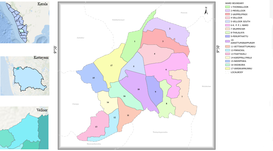
Velloor Grama Panchayat – Map 2026
Velloor Grama Panchayat, located in Vaikom Taluk of Kottayam District, is a green and scenic rural region situated along the banks of the Muvattupuzha River. Covering an area of 19.29 square kilometres, the Panchayat is known for its agricultural prosperity, industrial heritage and excellent transportation facilities.
Ward-wise Geographical Distribution
The 17 wards of Velloor Grama Panchayat are geographically distributed in the following directions.
⬆️ Northern Region
01. Thonnalloor
02. Mevelloor
03. Vaippelppady
➡️ Eastern Region
06. KPPL Ward
07. Irumbayam
08. Thalalaya
09. Perunthattu
⬇️ Southern Region
11. Vettikkattumukku
12. Paraykkal
13. Thattaveli
14. Karippallimala
⬅️ Western Region
15. Neerpara
17. Varikkamkunnu
📍 Central Region
04. Velloor
05. Velloor South
10. Arattumanappuram
16. Vadakara
🗺️ Ward Delimitation Map
To view the ward delimitation map of Velloor Grama Panchayat, please visit the link given below.
Velloor Grama Panchayat | Kottayam District


