

Map 2015
🗺️ Velloor Grama Panchayat – Map 2015
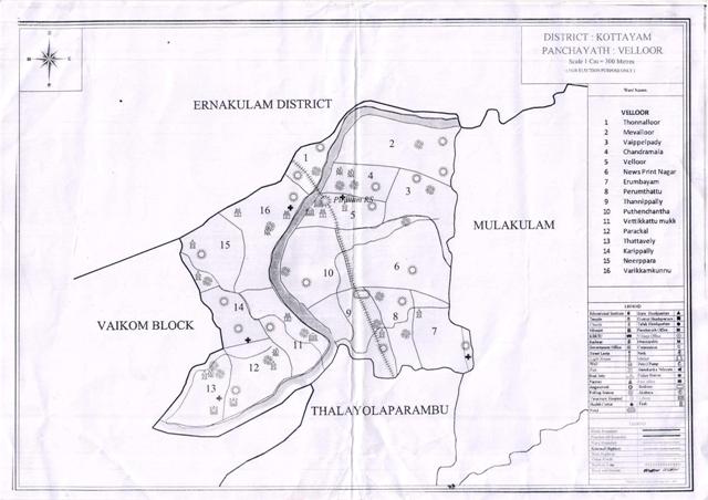
Velloor Grama Panchayat – Map 2015
Velloor Grama Panchayat is an important local self-government institution situated in Vaikom Taluk of Kottayam District. The Panchayat is bounded by Ernakulam District in the north, Mulakulam Grama Panchayat in the east, Thalayolaparambu Grama Panchayat in the south and Vaikom Block Panchayat in the west. The Panchayat comprises 16 wards. It is progressing along the path of development through a harmonious blend of agriculture, industry, education and cultural heritage. The geographical layout and ward-based administrative system provide a strong foundation for participatory development activities.
Ward-wise Geographical Distribution
Velloor Ward (5) is situated in the central part of the Panchayat. Surrounding it are wards such as Mevelloor (2), Vaippelppady (3), Chandramala (4), Irumbayam (7), Perunthattu (8), Puthanchantha (10) and Varikkamkunnu (16).
⬆️ Northern Region
01. Thonnalloor
02. Mevelloor
03. Vaippelppady
➡️ Eastern Region
06. Newsprint Nagar
07. Irumbayam
08. Perunthattu
09. Thannippally
⬇️ Southern Region
11. Vettikkattumukku
12. Paraykkal
13. Thattaveli
⬅️ Western Region
14. Karippally
15. Neerpara
16. Varikkamkunnu
📍 Central Region
02. Mevelloor
03. Vaippelppady
04. Chandramala
05. Velloor
07. Irumbayam
08. Perunthattu
10. Puthanchantha
16. Varikkamkunnu
Velloor Grama Panchayat
Vaikom Taluk | Kottayam District | Kerala
Historical Ward Map – 2015


